
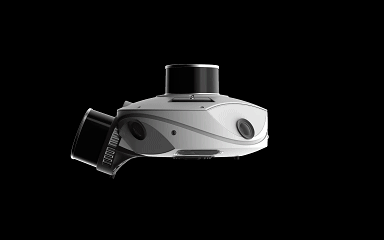
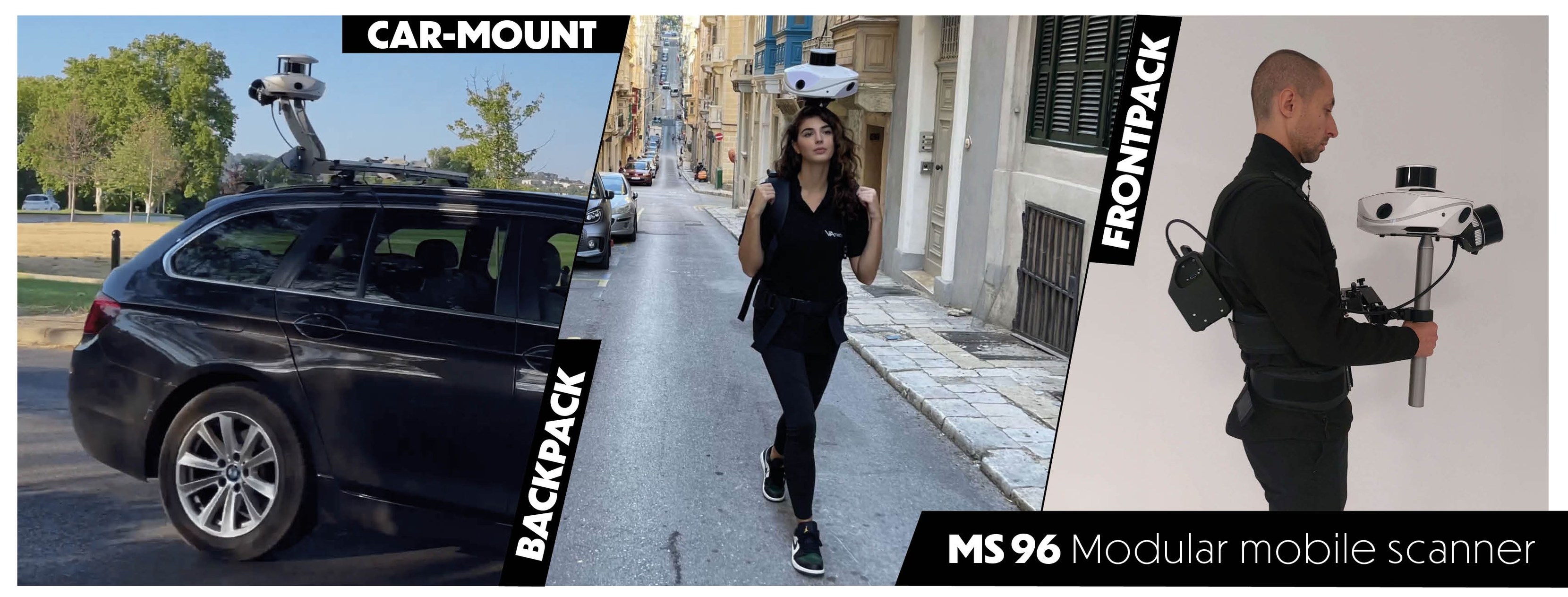
MS-96 is a unique solution that integrates a SLAM algorithm, a high end Inertial Measurement Unit (IMU), and a Global Navigation Satellite System (GNSS) receiver, designed to meet the diverse needs of surveying professionals. With its outstanding modular design, it can satisfy the requirements and constraints of surveyors, topographers, architects, BIM modelers, and construction professionals. This device can be used both indoors and outdoors and adapts to various mobile scenarios: it can be worn as a backpack system, used as a walking version via its articulated arm, or mounted on a vehicle or even a scooter. Combined with a millimeter-noise LiDAR sensor and a proprietary 96-megapixel camera, it generates highly accurate and visually rich point cloud data, providing a complete and efficient solution for even the most demanding projects.
High Precision and Flexibility
The MS 96 Modular Mobile Scanner is designed for high-precision scanning with a 96 MP proprietary camera and modular sensor head. It features 1cm LiDAR precision and 5mm LiDAR accuracy, making it ideal for large-scale data capture in varying environments. Its GNSS compatibility allows for accurate positioning, ensuring reliable results in real-time operations.
Advanced Camera and LiDAR Technology
Equipped with four 24 MP cameras and advanced LiDAR technology, the MS 96 ensures detailed imaging and accurate distance measurements. The 20,000 lumens LED lighting system ensures effective data capture in low-light conditions. With its scan capacity of 320,000 points per second, this scanner is capable of delivering high-quality results at fast speeds.

Autonomous Operation and Portability
The MS 96 offers up to two hours of autonomous operation with dual lithium batteries. Its lightweight design (5.2kg) and portable configuration make it ideal for fieldwork, while the 1TB SSD ensures ample data storage. The scanner's system status stripe provides real-time feedback on its performance, enhancing the overall user experience.
Efficient Fieldwork Tool
The MS 96 Modular Mobile Scanner delivers precise scanning with 96 MP cameras and advanced LiDAR technology. It ensures fast, high-quality data capture with GNSS support. Portable and lightweight, it's ideal for fieldwork with up to two hours of battery life.

Ambit Geospatial Solution and third parties collect personal information as specified in the privacy policy and use cookies or similar technologies for technical purposes and, with your consent, for experience, measurement and marketing (personalized ads) as specified in the cookie policy.
You can freely give, deny, or withdraw your consent at any time by accessing the preferences panel. Denying consent may make related features unavailable.
Use the “Accept” button to consent. Use the “Reject” button to continue without accepting.