
AMBIT is a technology company that focus on city-wided “Big Data” acquisition and analysis by using our developed aerial robotic machine (UAV/UAS/Drone/Aerial Camera) and geospatial software. We focus solely on enterprise application including. environmental, agricultural, land surveying, planning and construction engineering fields. We targets as one of the best independent geospatial consultant company in the world; having developed a tradition of excellence in providing professional GIS services to government and a broad range of industries internationally. Throughout these years our GIS team had worked together with various engineering expertise using innovative geospatial technologies to resolve project challenges. Our staffs have built decades of success in multi-disciplinary GIS services including engineering, environment, planning as well as water applications. We are total geospatial solution provider supplying both data acquisition hardware and geospatial analysis software as well as services to our client. We specialize in 3D geospatial system (3D GIS), terrestrial and aerial photogrammetry mappings and manufacturing of professional aerial mapping drone and camera.
Surveying & Mapping
Oblique photogrammetry, which is a new technology within the field of photogrammetry, has become a major focus of global research. Oblique Photogrammetry intensive multi-view image matching algorithm is more complicated than the current digital image matching. Due to the inclusion of additional data sources, particularly multi-view images, the matching process must simultaneously address matching time, speed, and reliability considerations. Consequently, generating 3D models using oblique photogrammetry typically incurs higher costs. Ambit offers the first affordable total solution for oblique photogrammetry, covering the entire workflow from data acquisition to 3D model generation.
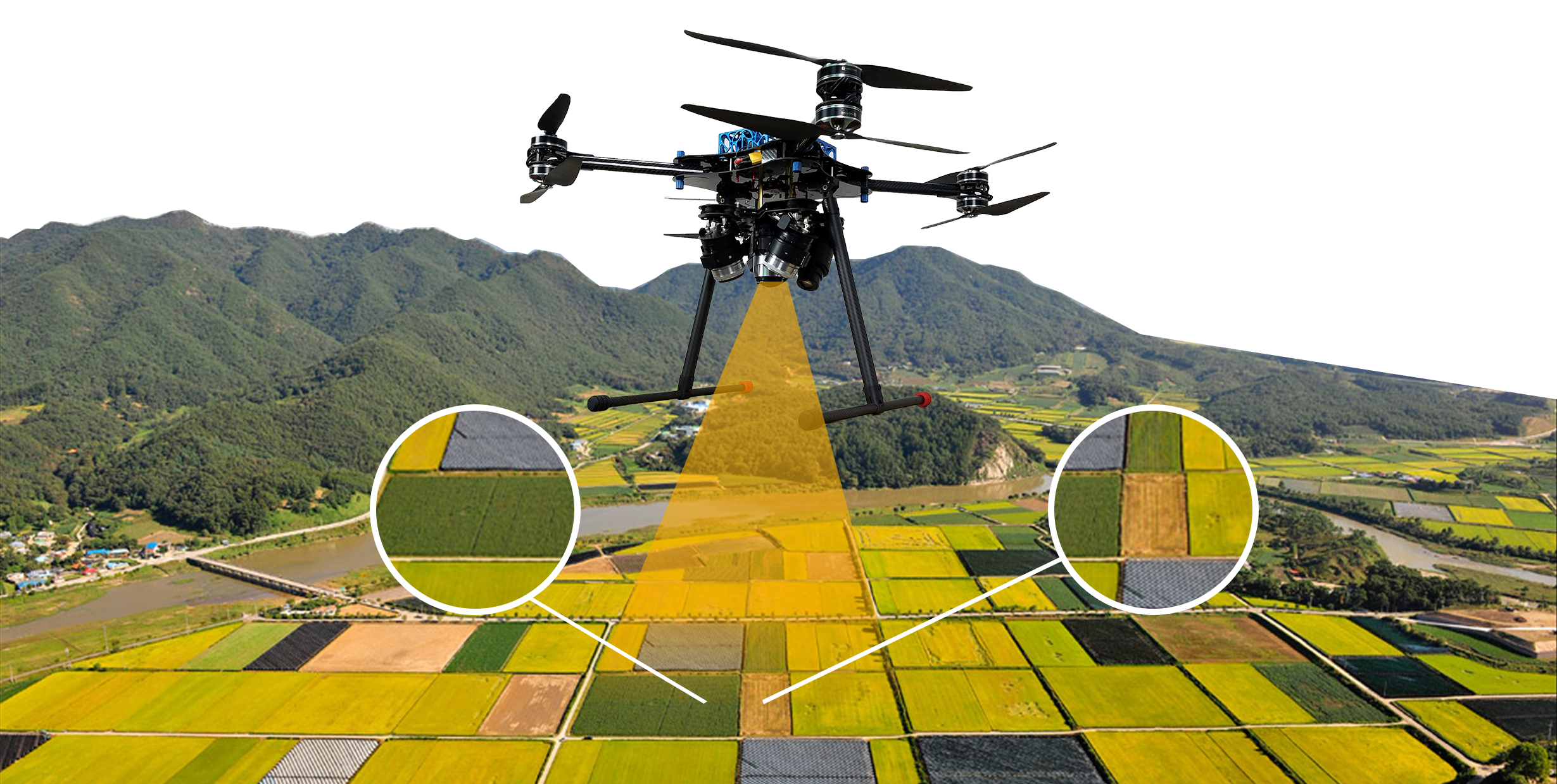
Precision Agriculture
For generations farmers have walked their fields investigating crops manually for signs of stress or disease. This traditional, labor intensive method is time consuming and can be difficult when crop canopies thicken. With Eagle-Eye ,farmers are able to evaluate their crops at scale while simultaneously creating crop maps that help them manage crops and time better.
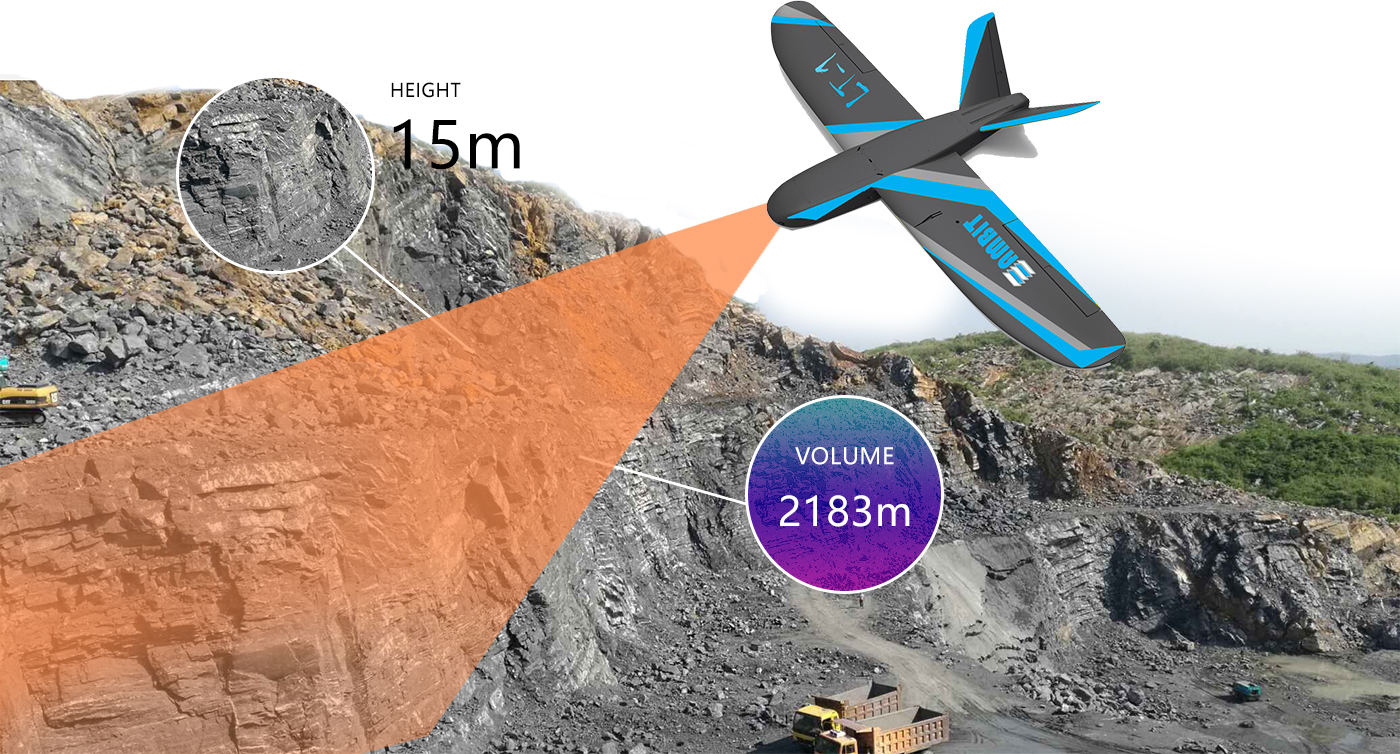
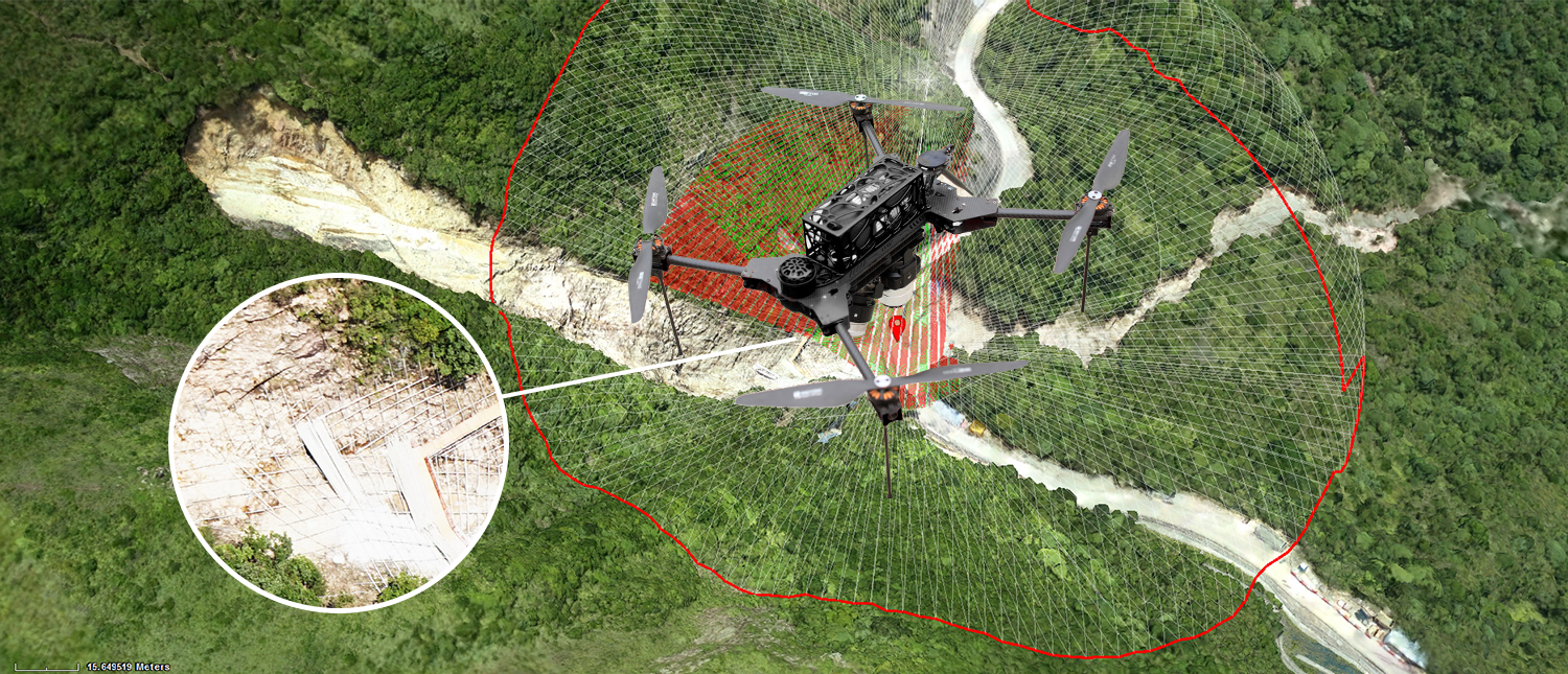
Mining & Aggregates
Oblique photogrammetry is an innovative technology gaining traction in mining and aggregates, leveraging advanced multi-view image matching to generate highly detailed and accurate 3D models. This process involves handling large data sets from multiple perspectives, requiring careful consideration of matching time, speed, and reliability. Traditionally, creating 3D models with oblique photogrammetry has been costly and complex. However, our company provides an affordable, end-to-end solution, covering everything from data capture to the generation of precise 3D models. This enables efficient planning, monitoring, and management of mining and aggregate operations with greater accuracy and cost-effectiveness.
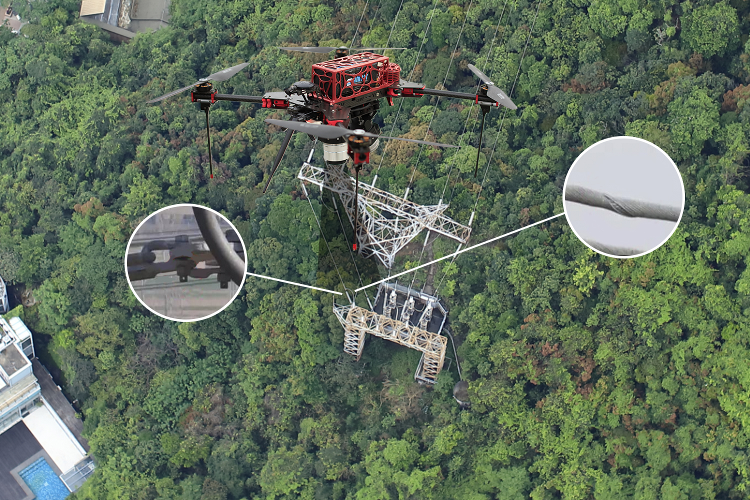
Process Power & Utilities
Unmanned aerial vehicle (UAV) is an advanced, autonomous aircraft that operates without a pilot on board. A UAV transmission line inspection system is a complex integrated system that combines aviation, power transmission, electricity, meteorology, telemetry and remote sensing, communications, geographic information systems (GIS), image recognition, and information processing. It incorporates advanced technologies including flight control, airframe stability control, data link communications, modern navigation, airborne telemetry and remote sensing, fast-focus camera systems, and fault diagnosis. Modern UAVs are capable of high-altitude, long-distance, and high-speed operations, as well as autonomous flights. They can traverse mountains and rivers to rapidly patrol power transmission lines, inspecting towers, brackets, wires, insulators, vibration dampers, suspension clamps, and other components, while capturing comprehensive video footage and monitoring for faults.
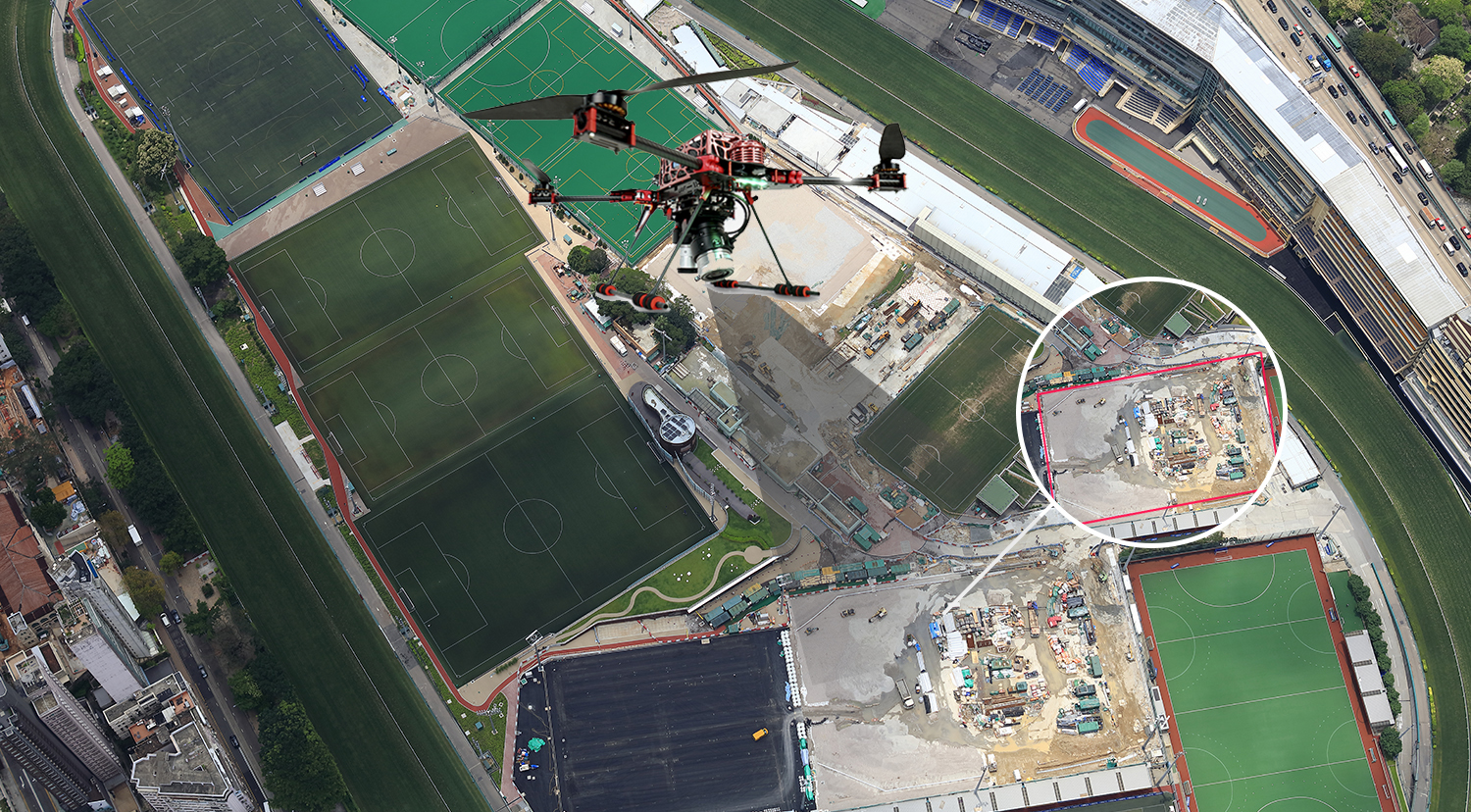
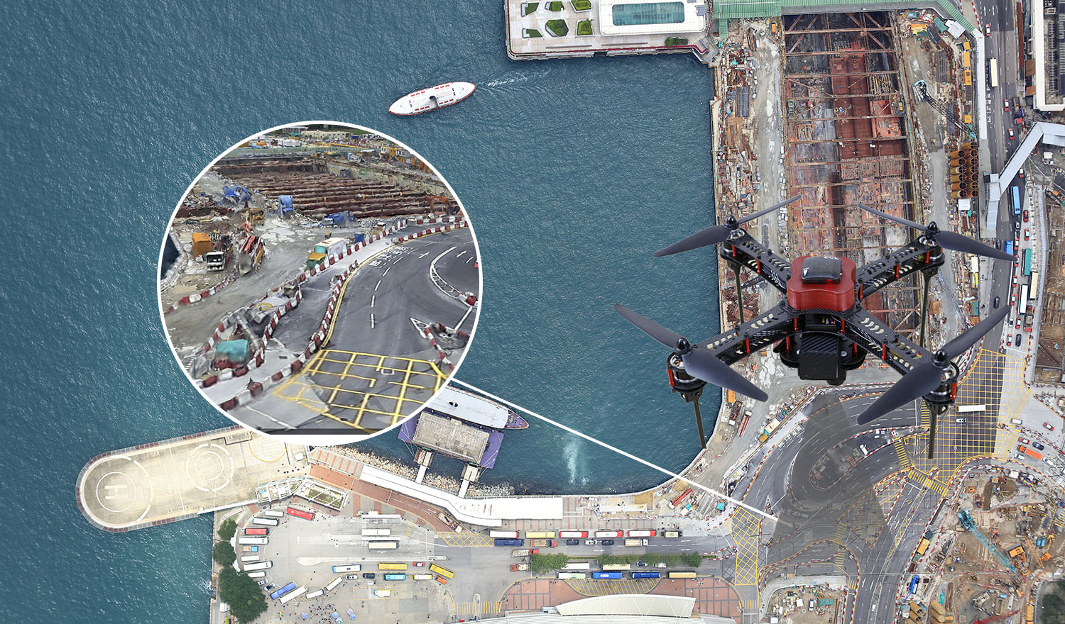
Civil Infrastructure
With the rapid development of urban construction, much of our infrastructure is under increasing pressure to ensure the efficient operation of cities. Therefore, how to plan, design, manage, and maintain infrastructure has become an important challenge for managers. Our UAV surveying solutions can contribute to addressing these challenges. Aerial images captured by UAVs can be easily transformed into accurate 2D orthophotos, maps, and 3D virtual models that can be explored using computer software. These 3D models help managers identify defects in existing infrastructure and simulate how infrastructure would perform under crisis conditions. They also enable visual inspections and metric measurements of UBW. The collected data allows experts to evaluate the needs of the city system and helps them work more effectively. Our UAVs can also be equipped with other types of cameras, such as thermal sensors and multispectral sensors, for engineering or security applications, helping to detect hidden risks within infrastructure.
Law Enforcement,Emergency Response & Search and Rescue
In recent years, many technological breakthroughs have emerged in areas where they were least expected. Unmanned Aerial Systems (UAS), for example, have evolved from primarily military focused applications into tools with a wide range of commercial uses across many industries. But what makes UAS valuable for emergency response? One key advantage is their ability to provide aerial views, which are extremely useful in large-scale disaster zones. Drones are designed to be agile, fast, and durable, giving response teams a significant advantage while costing far less than manned flight operations. Because many drones can operate autonomously, they are able to reach hard-to-access areas and carry out data collection tasks that would otherwise be unsafe or impossible for humans. Ambit provides an affordable, end to end aerial solution designed to support law enforcement, emergency response, and search-and-rescue operations.
Ultra High Resolution 3D Mesh Model
Using UAV photography, our technology generates an ultra-high-resolution 3D mesh model of Jumbo, ensuring remarkable detail and accuracy. This process captures complex structures, offering precise orthomosaics and 3D reconstructions.
Perfect for professionals seeking advanced mapping and modeling solutions, this model provides unparalleled clarity and is ideal for large-scale projects where precision matters.
Ambit Geospatial Solution and third parties collect personal information as specified in the privacy policy and use cookies or similar technologies for technical purposes and, with your consent, for experience, measurement and marketing (personalized ads) as specified in the cookie policy.
You can freely give, deny, or withdraw your consent at any time by accessing the preferences panel. Denying consent may make related features unavailable.
Use the “Accept” button to consent. Use the “Reject” button to continue without accepting.