
| SkylineGlobe Web Package (SGWP) is a complete out-of-the-box web application for publishing interactive 2D and 3D geospatial environments that increase understanding and improve decision making. Your website users can navigate through an intuitive, virtual environment, viewing, analyzing, and annotating data in its geographical context. With a powerful community tool and online publishing capability, SGWP promotes project collaboration and data sharing. Other robust capabilities include extensive raster and feature layer support, powerful drawing tools, advanced analysis tools, and search functionality. | 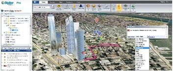 |
Using the SGWP’s Manager interface, you can customize your application to your organization’s needs, from the included data layers to the application tools and commands. If your application is intended for multiple target audiences (e.g. groups of interest or different user privileges), you can easily create customized subsites, so that each group sees only the data and tools that are relevant or of interest to it.
Explore
Users can navigate in their 3D environment using any combination of the wide range of available methods. Flexible free flight modes and tools enable users to fluidly explore their 3D environment. Users can also navigate via the Project Tree or by searching for a specific location using SkylineGlobe’s built-in search function.
Search
The application’s search function can be based on the Web Package’s included gazetteer or customized to connect to the organization’s own search engines. The search capability can be further enhanced by integrating turn-by-turn routing services so users can get directions from any starting point to any end point.
Analyze
SGWP increases understanding and improves decision making with powerful analysis tools, including Terrain Area, Line of Sight, Viewshed, Threat Dome, Flood Analysis, and Volume Analysis. The tools offer extremely flexible measurement and display options so that you can easily calculate and visualize the information you need.
Share
The SkylineGlobe Community tool provides peer-to-peer collaboration capabilities within an organization, enabling users to invite other SkylineGlobe users to fly-through, annotate, and analyze a 3D environment together. All projects and project data can be freely published and shared with all or specific users in one’s organization, promoting greater organizational efficiency and productivity.
Annotate
Users can overlay the terrain with geo-referenced, satellite or aerial images and geo-referenced elevation raster, as well as feature layers. With support for a wide range of layer formats, databases, and web services, SGWP enables you to integrate massive and disparate datasets into a seamless mosaic. Using SkylineGlobe’s advanced drawing tools, geospatial understanding can be further enhanced by adding and editing advanced 2D and 3D shapes, pre-prepared 3D models, video, and dynamic objects.
Customize
Using the Web Package’s SkylineGlobe Manager, you can easily tailor your application to your organization’s needs. Define what layers should be available and which search providers should be used. Create custom tools using HTML or JavaScript files and then customize your ribbon, adding the new tools and making other required modifications. If your application is intended for multiple target audiences (e.g. groups of interest or different user privileges), you can easily create customized web applications (subsites), so that each group sees only the data and tools that are relevant or of interest to it.
- SkylineGlobe 3D Web Application - 3D web application with an extensive set of tools and capabilities.
- Advanced Capabilities - Additional features are available for web users with a TerraExplorer Pro or Plus license.
- SkylineGlobe 2D Web Application - 2D web application in which users can navigate, search, and edit customized 2D maps.
- 2D Mobile Web Application - 2D web application that provides mobile access to your 2D maps.
- Management & Customization
- SkylineGlobe Website Administration - A back-end, web-based application, that enables you to easily manage and customize your application.
- API Development - API extensions for the development of customized SkylineGlobe web tools.
- Download PDF document: SkylineGlobe Web Package v6.5